| A. | Abbasid Ceramics: | |||
| The Historical Background | ||||
The first Islamic dynasty, the Umayyads, fell in the year 750, victim of a new and popular ideology, which proclaimed the necessity of returning to the right observance of the Qur’an and Sunna, and that all Muslims should enjoy the same rights without any discrimination based on ethnic origin or date of conversion. The main proponents of this new ideology were the movements of the ‘Alids – who claimed descent from the Prophet’s brother-in-law, ‘Ali ibn Abi Talib – and the Abbasids – who claimed descent from al-‘Abbas, the Prophet’s paternal uncle. Thus, they invested the new ideology with a religious aspect: accusing the Umayyads of betraying real Islam, they claimed that order and justice could only be restored if political power were returned to the family of the Prophet.
Open revolt broke out in 747, during the reign of Marwan II (744-750): the Abbasids had as their emblem black standards, which were unfurled at Merv in Khurasan, symbolising the launch of a military attack against the Umayyads, who were denounced as “enemies of the family of the Prophet”. At the outset, they seized the whole of Khurasan, then advanced towards Iraq. One wing of the Abbasid army won a victory over Umayyad troops at Kufa in September 749, and a second wing won the decisive battle of the Great Zab, on a tributary of the Tigris, in February 750.
This sealed the fate of the reigning dynasty: Marwan II fled with his troops to Syria and then Egypt, where he was murdered a few months later; a ferocious massacre of all members of the Umayyad family ensued, in Syria where they had been lured into an ambush by the new Abbasid caliph, in an attempt to eliminate all danger of a political recovery. The only one to escape was Abd al-Rahman, who escaped to the Maghreb and then Spain (al-Andalus) where he founded an Umayyad emirate. In the C10th, this declared itself the heir of the Syrian Umayyad Caliphate (q.v. Spain section).
The Abbasid Caliphate claimed to inaugurate a new era of justice, piety and happiness. All its rulers were members of the Prophet Muhammad’s family, and aimed to show, by means of the throne-names which they adopted, that they had the blessing of divine support. The Umayyads, on the other hand, were seen as impious usurpers, and there is some re-writing of the history of the Umayyads by polemical, Abbasid-sponsored historians at this time. Even modern historians have seen this “revolution” as the victory of Iranianism over Semitic Arabism, but it is clear that many Arabs (especially Yemenis) took part in the insurrection. The revolutionary aspect of the new administration seems to have consisted essentially in the replacement of elite Syrian mawali (clients of the ruling party) with Iraqi and Persian mawali, who had been the strongest supporters of the fledgeling Abbasid movement. These ‘newcomers’ were thus allowed access to administrative posts from which they had previously been excluded.
In inevitable response to the provenance of the new dynasty’s power-base, the centre of gravity shifted east to Iraq, and the Islamic empire was transformed into an empire that was more Asian than Mediterranean. The dynasty’s early years, however, were characterised by an atmosphere of struggle and repressive police measures, as its rulers sought to consolidate their political control, and it seems that the motivation for the second Caliph, al-Mansur (755-775), leaving his capital at Hashimiyya (between Kufa and Hira) was his desire to get away from the “already crowded cities abounding in seditious elements” (Cambridge History of Islam, vol.I, p.111). Of course he obviously also wished to build himself a new residence which might be a symbol of power for the new dynasty.
After some experimenting with different sites, al-Mansur finally chose one not far from the old Sasanian capital of Ctesiphon, on an ‘island’ where the Tigris and Euphrates rivers are closest to each other (less than 40km apart) and are linked by a series of navigable canals. This provided a natural defense, but the site was also appealing because of its climate and the ease with which it could be provisioned. Here he began to build the famous circular city of Madinat al-Salam (the ‘City of Peace’), himself laying the first brick in summer 758, and al-Mansur took up residence in his new palace in 762. Here he transferred the court, treasury and army. The city’s shape was perhaps planned according to cosmological symbolism, with its ceremonial centre of palace and mosque at its heart, set in the middle of a huge open square and surrounded by the houses of the court dignitaries, and the barracks of the Caliph’s guards. The whole city was enclosed by a double wall, pierced by 4 monumental gates.
Madinat al-Salam was built quickly, occupying a huge labour force and craftsmen from all over the Islamic world. It seems that the organic city was already growing up around the foundations of the walled centre while building was still in progess, and this was the first stimulus for the boom in commercial growth in the east of the empire. Although it was initially intended as a dwelling for the Caliph and his entourage, Baghdad soon became the hub of an important, international, imperial centre.
[Click here to read an account of the visit of some Byzantine ambassadors to Baghdad]
Perhaps the same motivation of “getting away from it all” caused al-Mansur’s son, Muhammad ‘al-Mahdi’ (775-785), to build another private residence, at al-Rusafa, on the other bank of the Tigris. Harun al-Rashid (786-809) likewise abandoned Baghdad, in 796, to build a new city complex (named al-Rafiqa) near the Byzantine and Umayyad site of al-Raqqa, on the banks of the Euphrates in Upper Mesopotamia (now northern Syria). Here he added to the existing fortifications, and built palaces and living quarters. It remained his capital until 808 when he returned to Baghdad. However, Raqqa remained the regional capital of the Jazira province until the mid-tenth century, and was a place of refuge for Caliphs in exile, as well as the home of many renowned scholars (q.v. that section of the project).
After the death of Harun al-Rashid, civil war between his sons al-Amin and al-Ma’mun demonstrated need for the Caliph to have an armed force which was completely loyal to his person and not implicated in religious or other quarrels. As a result, his third son, al-Mu’tasim (833-842) began by forming his own guard of 4000 Turkish mercenaries, and continued to increase this number by importing Slavs and even Berbers from the West. It is reported that his army grew to nearly 70,000, and eliminated the Khurasanis who had represented the core of Muslim forces under the first Abbasid rulers. These slave mercenaries were frequently emancipated in reward for their services and then enrolled in high offices in the palace or government, which naturally had implications for the dynasty and society as a whole. The foundation of the new Abbasid capital at Samarra is usually credited to the fact that the Caliph al-Mu’tasim’s personal guard had created so much resentment amongst the inhabitants of Baghdad by their bad behaviour that the Caliph was forced to build himself a new capital outside of Baghdad.
| a. | Introduction | ||
Samarra is the biggest archaeological site in the world: located 125km (60 miles) upstream from Baghdad, its ruins cover a length of nearly 50km along one bank of the Tigris, and 8km at their maximum width. The built-up area extended to about 57km2 of ruins, spread over a region of about 150km2. In total, 6,314 constructions have been registered on the site, only 9 of which “have any meaningful vertical dimension to record” (see Northedge’s article in the Encyclopædia of Islam).
Most of these 9 can be dated to several construction phases within the 56-year period between 836 and 892, when Samarra was the official caliphal residence for the Abbasid Caliph and court retinue, and cantonment for his Turkish troops and guards. The period 836-892, when we know the site was occupied, has been called the “Samarra horizon” (q.v.), and traditionally archaeological finds from the site have been dated to within this short period.
However, the site was occupied much earlier than this: it was the site of a Sasanian settlement, and the major water distribution systems which supplied Samarra to some extent, the Nahrawan canal and the Nahr Isa (which formed the boundaries of the city on the East and West banks of the Tigris), were built by Shah Khusraw Anushirvan in the early C6th. Harun al-Rashid started to build an octagonal walled city, known as al-Qadisiyya, to the south of the city, supposedly when he tired of Baghdad, but it was never finished. Al-Mu’tasim, in his search for a new capital, found monasteries here, and the historian al-Ya’qubi reports that one of the monks told the Caliph the story of a former city on this site that would one day be rebuilt by a “great, victorious and powerful king”.
Building at Samarra occurs in a series of phases, stimulated by the increasingly magnificent projects of certain caliphs, the most significant being al-Mu’tasim and his son al-Mutawakkil (847-861). Al-Mu’tasim created a new city “almost overnight” (see Hodges and Whitehouse), by marking out distinct plots of land for military and civil functions; assigning his various troops to ethnic ghettoes; distributing districts to individuals among his family, friends and officials and thus passing to them the responsibility and expense for constructing the main public buildings in that area, such as “bazaars, bath-houses and mosques for their followers” (according to al-Ya’qubi). Al-Mu’tasim’s architects laid out the main streets which ran parallel to each other along the coast of the Tigris, and the Shari’a al-A’zam grew to a final length of 30km during the life of the site. The markets were located around the great Congregational Mosque, in zones according to the different merchandise or manufacture.
Lastly al-Mu’tasim imported craftsmen from all over the Islamic world, as well as materials for the more luxurious building ornament. The buildings themselves were made from sun-dried brick with some use of harder baked brick, which provided a very quick and cheap building method. This can be seen particularly in the foundation of the Caliph al-Mutawakkil’s new district to the north, known as ‘al-Ja’fariyya’, which took only 3 years to construct between 859-861 (when he was assassinated), but by then it was already 40km (20 miles) long and included a new palace which covered over 1km2, houses, bazaars, and a new Congregational Mosque (‘Abu Dulaf’).
 |
The geographer Yaqut says that a total of 294 million dirhams was spent on the construction of palaces at Samarra, and he lists 19 palaces that al-Mutawakkil supposedly built (however, there is a problem in his text over what counts as a palace). The largest of them all, built by al-Mu’tasim but much modified and rebuilt by later Caliphs who continued to use it as their main residence and audience hall, was the Dar al-Khilafa or Jawsaq al-Khaqani, whose walls enclosed a total area of 175 hectares, 71 of which comprised gardens along the Tigris. A monumental flight of stairs 60m wide rose up the cliff from the coast of the Tigris to the Bab al-Amma which was the main reception area of the palace; beyond this was a courtyard 380m long with residential quarters all around it. The barracks beside it to the north would have accommodated an estimated 3000 of al-Mu’tasim’s guards, and even that is only allowing for one storey.
The Balkuwara Palace was built in the south of the city for al-Mutawakkil’s second son, al-Mu’tazz, and was almost as large, set within a square inner enclosure measuring 1171m a side, and surrounded by a grid of streets which seem to have accommodated the large entourage of al-Mu’tazz. Other palaces included the Istabulat, the Musharrahat, the Qasr al-Ashiq, and the Ja’fariyya palace. Besides palaces and barracks, there were four huge racing tracks probably for horse-racing, with elaborate pavilions, game reserves (as this part of the steppe was renowned for its hunting), and a zoo in the grounds of the Musharrahat palace, home to all kinds of exotic animals. No wonder that the pre-Islamic name of the site (Samarra) was punningly adapted by the Arabs into “Surra Man Ra’a”, meaning “he who sees it is delighted”.
However, the most famous aspects to historians of Islamic art of this impressive archaeological site are the two enormous congregational mosques, the largest in the world, both built by al-Mutawakkil. The Great Mosque, built circa 848/9-852, is described by al-Ya’qubi: “[the Caliph] made it good and spacious and strong and placed a fountain within it which played without ceasing... He gave access to it by three wide rows coming from the street, and in each row were shops selling all sorts of merchandise and products of art and trade. The breadth of each row was [about 52m] so that the approach to the mosque was not too narrow for the Caliph when he visited the mosque on Fridays with his troops and followers, cavalry and infantry”. He also mentions how the Caliph allocated prestige spots near the qibla to his officials, friends and captains of his troops. Yaqut says that the cost of constructing this mosque was 15 million dirhams.
The mosque is constructed of baked bricks. It measures 240 x 156m, giving it an area of 38,000 m2. Its main axis is slightly off the true qibla, but all its features including its famous helicoidal minaret, al-Malwiyya (‘spiral’), are oriented on that axis. Its enclosing walls are 2.65m thick with 4 corner towers, 10 semicircular bastions along the length of all four walls. In this respect it seems like a huge fortress. In most of the alternating curtain walls between towers there are doorways, and they also all carry a frieze of 6 recessed squares with bevelled edges, which contain a shallow saucer coated with stucco.
The mosque was isolated from the hustle and bustle of the surrounding markets by a ziyada, which surrounded it on the east, north and west sides, and was itself inside a second ziyada surrounding all 4 sides. Inside there are 25 aisles in the main sanctuary, which is 9 bays deep; these aisles are perpendicular to the qibla wall whereas the side riwaqs are parallel to it. The arches stand on square piers which have an octagonal brick core, which was plastered over and given a marbled effect to match the coloured marble columns engaged at each corner. The ceiling rested directly on the top of the piers, and the distance from floor to ceiling was just over 10m. This is more than five times the height of the average man (who does not exceed 2m), and in these terms it is easy to imagine how al-Mutawakkil’s architectural statement in this mosque would have been awesome to his subjects
The mihrab was like a great doorway in the south wall of the mosque, reaching nearly to the ceiling, and there are traces of arches and columns by it, as well as gold mosaic and carved stucco decoration. It has two flanking doors which opened into rooms attached to the mosque, perhaps a rest or reception area for the Caliph. Al-Muqaddasi writes that the mosque rivalled that of Damascus in its decoration.
Al-Mustawfi says its central fountain was known as “Pharaoh’s Cup”, and that its basin was 23 cubits in circumference, standing to a height of 7 cubits, and half a cubit in thickness. Excavation has revealed fragments of marble columns and capitals, painted stucco, gilding and glass mosaics, showing it was richly decorated.
Lastly the mosque’s minaret stands at a distance of 27.25m from the north wall of the mosque, but connected to the mosque by a ramp ending in a narrow bridge. Its base was 33m a side, and the ramp (2.30m wide) ascends the helicoidal tower in an anti-clockwise direction until it has made 5 complete turns. The angle of ascent increases as it rises to compensate for the progressive reduction in the length of each complete turn. Holes at its edge suggest it may have had a wooden balustrade. At its summit there is a cylindrical storey decorated with 8 pointed-arched recesses, of which the southern-most niche is a doorway at which the ramp ends and gives on to a steep stairway leading to the top platform – here there was probably a pavilion. The whole minaret stands at some 52m high.
The Mosque of Abu Dulaf was built in a shorter space of time as well as a little later (circa 860-1), as the congregational mosque of the new district of Ja’fariyya. In contrast with the Great Mosque, its interior is comparatively well preserved but its outer walls are only indicated by long ridges. Its dimensions are all slightly smaller than the first mosque: the interior measures 213 x 135m, and the sanctuary contains 17 aisles and is 5 bays deep. All arcades run perpendicular to the qibla wall. The thick rectangular piers carry blind-niched panels with a narrow arched recess within them. The brickwork is inferior to the other mosque and is often set quite irregularly. It also had a flat wooden roof. The enclosing walls seem also to have had 4 corner towers and to have been strengthened by 11 intermediate bastions east and west, and 8 on the north and south sides. An enclosure (ziyada) surrounds the mosque on 3 sides and is in turn surrounded by mud brick walls, making the whole complex measure 350 x 362m.
The mihrab was an elaborately carved niche in the wall, with a flanking door leading into a “resthouse” for the Caliph, which included 2 courtyards (the one behind the mihrab being an early example of the four-iwan plan). This small complex allowed the Caliph “safe and immediate access” (according to al-Jannabi) to the mihrab when he came to lead the prayer on Fridays and public holidays.
This is another helicoidal tower, oriented on the north-south axis of the mosque. It stands 9.60m from the north wall, and its base is 11.20m a side. It is entered from a ramp on the south side, and its spiral ascent is cut through the solid brickwork of the plinth for its first quarter revolution. The stairway is 1m wide, and gives 3 anti-clockwise turns before reaching a height of 16m, but was thereafter badly damaged. (However, since Creswell first calculated these dimensions, the minaret has been fully restored.) Al-Tabari reports that al-Mutawakkil led the Eid prayer in this mosque at the end of Ramadan 861 and “no-one prayed in Samarra” (ie. the district to the south). Four days later the caliph was murdered and his son al-Muntasir abandoned the new city and ordered all the building materials to be brought back to Samarra.
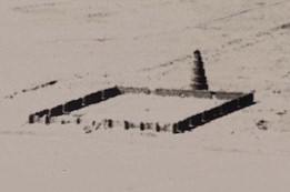
The spiral minarets are one of the most distinctive and famous aspects of Samarra. The tradition of spiral towers in Mesopotamia probably ultimately derives from the Babylonian ziggurat, the type – represented in the painting of the Tower of Babel by Brueghel [find pic] and other early modern depictions – as a square-based spiral tower with an outer staircase, though there is some question whether ziggurats were ever circular, as the most common type seems to have been rectangular.
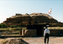 |
View of the ziggurat at Chogha Zanbil in Iran
There was a tower in Baghdad built for “secular purposes” (Creswell doesn’t say what these were!) by the Caliph ‘Ali Muktafi, circa 902-8, which was ascended by a spiral stair of such an easy gradient that he could ride to the summit on his donkey. The tower was thus given the name ‘Qubbat al-Himar’, the use of the word ‘qubba’ also suggesting that it had a domed pavilion at its summit, from which the Caliph could survey his city. This C10th tower must have derived from the minarets at Samarra.
The distinctive spiral-shaped minarets are also one of the most obvious echoes of Samarra in the Mosque of Ibn Tulun in Fustat, of which the C11th writer al-Quda’i (quoted by Ibn Duqmaq and al-Maqrizi) says that it was built ‘ala bina’ [ie. after the style of] the mosques of Samarra. This was probably a deliberate political statement on the part of Ibn Tulun, who was initially the Abbasid governor of Egypt, but then declared himself an independent ruler [click here or on the button below to read about the mosque of Ibn Tulun]. However, the same fable about the design of these minarets – geographically so distant from each other – is even related in the Arab sources: the Caliph/governor, was one day toying with a piece of paper round his finger and accidentally formed a spiral which he then told his architect to use as a model for the minaret of his new mosque. The fact that the same fable is attached to both the different mosques implies that some connection between them was evident to the Arab historians.
 |
J.M.Rogers derives from his analysis of Samarra and Baghdad the theory of the “town as glorious garment of the ruler”. He sees a five-tiered pattern in the life of Samarra:
1) the first stages of magnificence in building in Baghdad under al-Mansur and al-Mahdi;
2) new feelings of freedom at the spaciousness of Samarra which leads to the developments of al-Mu’tasim and his son al-Wathiq;
3) “the prodigality of al-Mutawakkil at the cost of all economy and convenience”;
4) disaster (the assassination in 861 of al-Mutawakkil) followed by immediate contraction, itself followed by
5) a return to Baghdad, and even greater architectural excesses, focused on individual buildings as the city is already so built up.
The more fertile west bank of the Tigris was left substantially undeveloped, which suggests that the priority in Samarra was not the creation of an organic town that relied on and stimulated the economy of its hinterland, but instead the “concentration on the exterior manifestation of prosperity”. The port on the Tigris, since flooded and obliterated by changes in the river’s course, brought imports of foodstuffs and luxury goods straight to the Caliph’s front door, and this rich market helped to stimulate trade in the Persian Gulf and the Indian Ocean. Rogers points out that the water supply at the site was incredibly deficient for the demands made on it, principally for aesthetic purposes like the huge fountain in the main courtyard of the Dar al-Khilafa, and the literary sources record that the lowlier inhabitants of Samarra had to draw their water from the river.
It is this combination of factors which mean that once the caliphal presence has been removed from the area, the stimulus for trade has also gone, and follows the court back to Baghdad leaving only a small population occupying only parts of the city, right up to the present day. The Samarran mint continued to produce silver dirhams until 953, and various tombs in the city become important pilgrimage sites, especially for Shi’i Muslims.
Cambridge History of Islam, edd. P.M. Holt, A.K.S. Lambton and B. Lewis; vol.1: The Central Islamic Lands (Cambridge, 1970); Part 1, chapters 3 (“The Patriarchal and Umayyad Caliphates”) and 4 (“The Abbasid Caliphate”)
Northedge, Alastair, “Samarra”, Encyclopædia of Islam article (written 1991)
Rosser-Owen, Mariam, The Political Initiative for the Mosque of Ahmad ibn Tulun: Imitating Samarra? (unpublished M.St. dissertation, Trinity Term, 1997)
To read more about Samarra and the excavations that are being conducted by Alistair Northedge and Derek Kennet, go to the Samarra Archaeological Survey website at: http://www.dur.ac.uk/~drk0dk/samarra.htm.